


Clocher de Tourmente 488 +

claude nier
User
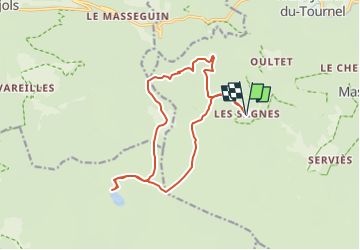

Length
16 km

Max alt
1444 m

Uphill gradient
488 m
Km-Effort
22 km

Min alt
1146 m

Downhill gradient
487 m
Boucle
Yes
Creation date :
2025-01-26 17:53:14.335
Updated on :
2025-01-26 17:54:23.096
5h06
Difficulty : Medium

FREE GPS app for hiking
 SityTrail
IGN / Geographical institutes
SityTrail Plus
The world is yours!
About
Trail On foot of 16 km to be discovered at Occitania, Lozère, Mont Lozère et Goulet. This trail is proposed by claude nier.
Description
Depart les Sagnes
Positioning
Country:
France
Region :
Occitania
Department/Province :
Lozère
Municipality :
Mont Lozère et Goulet
Location:
Saint-Julien-du-Tournel
Start:(Dec)
Start:(UTM)
552585 ; 4924658 (31T) N.
Comments